
 Why Did the Myanmar Earthquake's Devastating Effects Reach So Far? Understanding the Supershear Phenomenon

Have you ever wondered how an earthquake can cause destruction over 1000 kilometers away from its origin? The recent Myanmar disaster provides shocking answers!
Welcome, dear readers! We at FreeAstroScience are thrilled to share this in-depth exploration of one of the most destructive earthquakes of 2025. As we navigate the complexities of this seismic event together, we invite you to join us on this fascinating scientific journey. Whether you're a geology enthusiast or simply curious about our planet's powerful forces, we encourage you to read until the end to gain a comprehensive understanding of this extraordinary natural phenomenon.
What Happened During the Myanmar Earthquake?
On March 28, 2025, a powerful magnitude 7.7 earthquake struck Myanmar (formerly known as Burma), causing widespread devastation across the country. The earthquake originated near Mandalay in the north and ruptured along the Sagaing Fault, a major geological feature that runs north-south through the center of the country.
The human cost has been staggering. Latest reports indicate over 2,700 deaths and 4,500 injuries, though these numbers are likely underestimates given the severity of the disaster and limited response capacity. The USGS PAGER system estimated a 67% chance of more than 10,000 fatalities.
Beyond the immediate epicenter, the earthquake caused surprising damage in distant locations, most notably collapsing a high-rise building in Bangkok, Thailand—more than 1000 kilometers away from the epicenter. This unexpected far-reaching impact left scientists scrambling to understand the mechanics behind such extensive destruction.
Why Is the Sagaing Fault Geologically Significant?
The Sagaing Fault is part of a complex fault system that runs north-south through central Myanmar. This fault system accommodates movement between the Burma Plate and the Sunda Plate. From a geological perspective, it's classified as a strike-slip fault approximately 1200 kilometers long.
What makes this fault particularly interesting is its ability to generate major earthquakes. The recent earthquake, however, didn't rupture the entire fault length—only a section went through failure. Initial estimates suggested a rupture length of about 200 kilometers, but subsequent analysis revealed something much more remarkable.
The Sagaing Fault plays a crucial role in the regional tectonics of Southeast Asia, acting as a boundary that allows the Burma microplate to move relative to the Sunda Plate as part of the broader India-Asia collision zone. This movement accumulates strain over time until it's suddenly released in earthquakes like the one we just experienced.
What Made This Earthquake So Unusually Destructive?
When geologists and seismologists began analyzing data from the Myanmar earthquake, they quickly realized they were dealing with something extraordinary. What initially appeared to be a "typical" magnitude 7.7 earthquake turned out to have several unusual characteristics:
1. An Exceptionally Long Rupture
The initial estimates of the rupture length were around 200 kilometers, which would be expected for an earthquake of this magnitude. However, as more data became available, scientists revised this estimate dramatically upward. Using advanced techniques like back-projection and sub-event inversion, researchers determined that the actual rupture length was between 350-480 kilometers—more than twice the initial estimate!
This extraordinary length means that many more populated areas, including Myanmar's capital city of Naypyitaw, were located very close to the rupture itself, experiencing severe shaking and direct fault-related deformation.
2. The "Supershear" Phenomenon
Perhaps the most fascinating aspect of this earthquake was its rupture velocity. Typically, fault ruptures propagate at around 2-3 kilometers per second. However, the Myanmar earthquake showed evidence of "supershear" rupture—a rare phenomenon where the rupture front travels faster than the speed of shear waves (S-waves) in rock.
The rupture velocity was calculated at approximately 4.4 kilometers per second—more than double what would normally be expected. This placed the Myanmar earthquake in a rare category of seismic events that includes less than twenty confirmed cases worldwide, all of them large earthquakes on strike-slip faults.
What Exactly Is a "Supershear" Earthquake?
To understand what makes a supershear earthquake special, we need to explore some basic earthquake physics.
During a normal earthquake, the rupture front (where the fault is actively breaking) travels through the Earth's crust at a speed slower than the S-waves it generates. S-waves, also known as shear waves, are a type of seismic wave that moves through rock with a side-to-side motion.
In a supershear earthquake, something remarkable happens: the rupture front accelerates to speeds faster than these S-waves. This creates an effect similar to a sonic boom in air—except it happens within solid rock! Scientists call this a "Mach wave."
When this occurs, areas in front of the rupture direction experience a sudden arrival of superimposed S-waves from different rupture moments, creating an unusually powerful pulse of seismic energy. This concentrated energy can cause more severe ground shaking than would normally be expected from an earthquake of that magnitude.
How Did Scientists Determine the True Extent of the Rupture?
Determining the true extent of an earthquake rupture, especially in a region with limited monitoring equipment like Myanmar, requires multiple scientific approaches. Here's how researchers pieced together the puzzle:
Back-Projection Analysis
This technique uses data from distant seismic arrays to track high-frequency bursts of energy during the rupture. Preliminary back-projection studies indicated that high-frequency energy was radiated along the Sagaing Fault between 18°N and 23.5°N—suggesting a rupture length of nearly 600 kilometers! Even considering the overlap from different seismic networks, the consensus data suggested a rupture of approximately 440 kilometers.
Sub-Event Inversion
Another approach modeled the earthquake as several different energy sources rather than a single idealized source. Dr. Zhe Jia's analysis presented two possible models: either a standard 180 km rupture at normal speeds (2 km/s) or a much longer 350 km rupture at supershear speeds (5 km/s). When tested against actual seismic recordings, only the supershear model accurately predicted the early S-wave arrivals observed at multiple monitoring stations.
Aftershock Distribution
The pattern of aftershocks provides additional clues about the rupture extent. The Myanmar earthquake produced aftershocks along a north-south corridor approximately 500 kilometers long, further supporting the hypothesis of an unusually extended rupture.
Interestingly, there was a 100-kilometer section between 20.5°N and 21.5°N with fewer aftershocks. This pattern is consistent with areas that experienced supershear rupture, which typically show less aftershock activity.
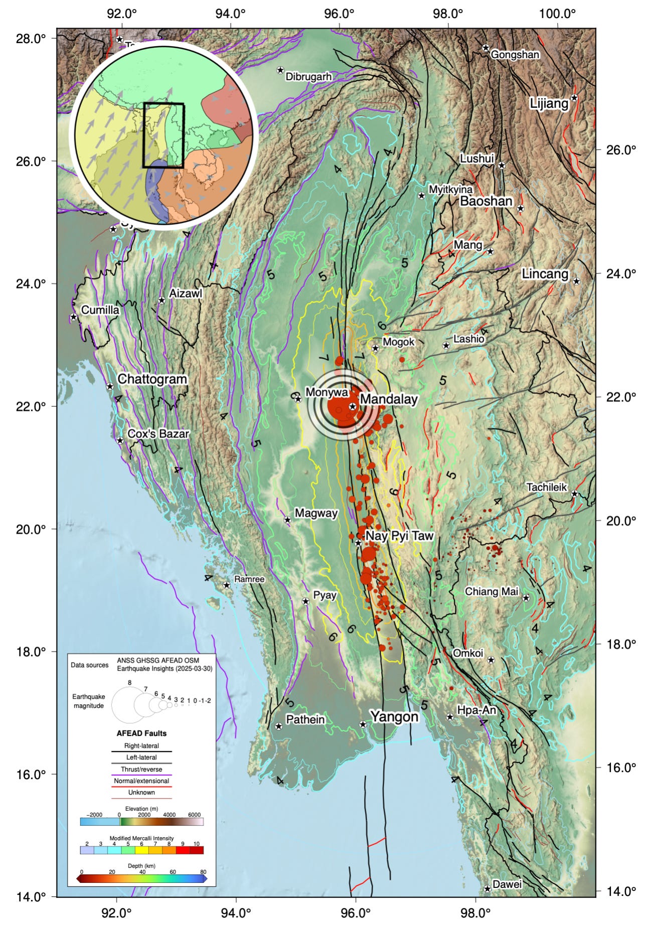
Figure: Map of the Myanmar earthquake mainshock and aftershocks (Thai network). Map also shows faults, colored by type, and contours of slip intensity estimated by the USGS.
Why Did the Earthquake Affect Bangkok So Severely?
One of the most perplexing aspects of this earthquake was the damage observed in Bangkok, Thailand—more than 1000 kilometers from the epicenter. How could an earthquake affect areas so far away?
The answer lies in a combination of factors:
1. The Extended Rupture Length
While Bangkok is approximately 1000 kilometers from the earthquake's epicenter in northern Myanmar, the southern end of the rupture was much closer—approximately 600 kilometers away. This significantly reduced the effective distance between the earthquake source and Bangkok.
2. The Supershear Effect
The supershear rupture created stronger ground motions over a broader area due to the "Mach cone" effect. This concentrated seismic energy in the direction of rupture propagation—which was southward, toward Thailand.
3. Site Amplification
Bangkok is built on soft alluvial sediments from the Chao Phraya River. These sediments can amplify seismic waves, a phenomenon known as site amplification. When seismic waves pass from hard bedrock into softer sediments, their amplitude increases, causing stronger shaking.
4. Building Resonance
Tall buildings have natural oscillation frequencies. If these frequencies match those of the incoming seismic waves, resonance can occur, causing the buildings to sway more dramatically. This phenomenon famously caused severe damage in Mexico City during the 1985 earthquake, despite the epicenter being 350 kilometers away.
What Can We Learn From This Earthquake?
The Myanmar earthquake of March 2025 offers valuable insights for seismologists, engineers, and disaster management experts worldwide:
Supershear earthquakes deserve special attention: Their ability to cause damage over unexpectedly large areas means we may need to reconsider hazard assessments for regions near major strike-slip faults.
Earthquake impacts aren't limited to near-epicentral regions: As demonstrated by the damage in Bangkok, earthquake effects can reach surprisingly far distances under certain conditions.
Multiple scientific approaches are needed: No single method would have revealed the full story of this earthquake. By combining different analysis techniques, scientists gained a much clearer understanding of this complex event.
Building codes matter: The widespread damage and high death toll highlight the importance of earthquake-resistant construction, especially in seismically active regions.
Regional seismic monitoring networks are invaluable: The ability to track aftershocks and analyze seismic data from nearby stations proved crucial in understanding this event.
Could This Happen Elsewhere in the World?
Supershear earthquakes have been documented on various strike-slip faults around the world, including the North Anatolian Fault in Turkey, the Kunlun Fault in Tibet, and the Denali Fault in Alaska. Any long, straight strike-slip fault potentially could host such an event.
Some of the world's most populated regions sit near major strike-slip faults, including California's San Andreas Fault, Turkey's North Anatolian Fault, and New Zealand's Alpine Fault. The Myanmar earthquake serves as a reminder that these faults could potentially generate similarly destructive events.
What Questions Remain Unanswered?
Despite the rapid scientific analysis, several questions about the Myanmar earthquake remain:
- What physical conditions allowed the rupture to accelerate to supershear speeds?
- Why did the rupture propagate so far to the south but not as extensively to the north?
- What role did the local geology play in the distribution of damage?
- How will this event affect the stress distribution on nearby faults?
Scientists will continue analyzing data from this event for years to come, gradually building a more complete understanding of this extraordinary earthquake.
Conclusion: Beyond the Tremors
The devastating Myanmar earthquake of March 2025 stands as a powerful reminder of our planet's dynamic nature and the forces that continuously shape Earth's surface. With its unusual rupture characteristics and widespread impact, this event has provided scientists with valuable data to improve our understanding of earthquake physics.
As we at FreeAstroScience reflect on this catastrophic event, we're reminded that scientific understanding isn't just academic—it has real implications for public safety and disaster preparedness. Every major earthquake teaches us something new about our planet's behavior and challenges us to refine our models, improve our building codes, and enhance our early warning systems.
The lessons from Myanmar will undoubtedly influence seismological research and earthquake engineering for years to come, potentially saving lives in future events. As we continue to study Earth's restless crust, each discovery brings us one step closer to greater resilience in the face of these powerful natural phenomena.
Post a Comment